Sea charts.
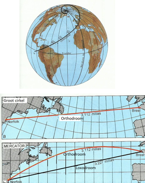
The Earth is a sphere and to represent it on a flat piece of paper requires an explanation of how the Earth's surface was “flattened”. The most well-known and used method is Mercator projection, a true-to-angle cylinder projection: the angles between all directions remain true to those of the Earth's surface. The meridians remain perpendicular to the parallels. Because the minutes on the meridians increase as you move away from the equator, also called a waxing map. The advantage of this projection is that a straight line between 2 points has a fixed course, a rhumb line named. However, the distance between these 2 points along that course line is not the shortest. The shortest distance is that according to the great circle over the 2 points and gives a trajectory with a constantly changing course. On the map this line is called a orthodromic and is a curve with the curve upwards in the Northern Hemisphere and downwards in the Southern Hemisphere.
Nowadays, modern navigation tools via satellites (GPS) are of course widely used, but these can fail or be turned off or even manipulated. These resources also use electrical power, which can run out. The chance of an emergency like one mentioned earlier is very small, but I have experienced it myself that the entire GPS system failed for a few hours during a crossing to Ibiza, due to what later turned out to be a US operation in Iraq.
But knowledge is power, so it is advisable to understand the old-fashioned methods, which also benefits from the use of GPS, plotters, etc.

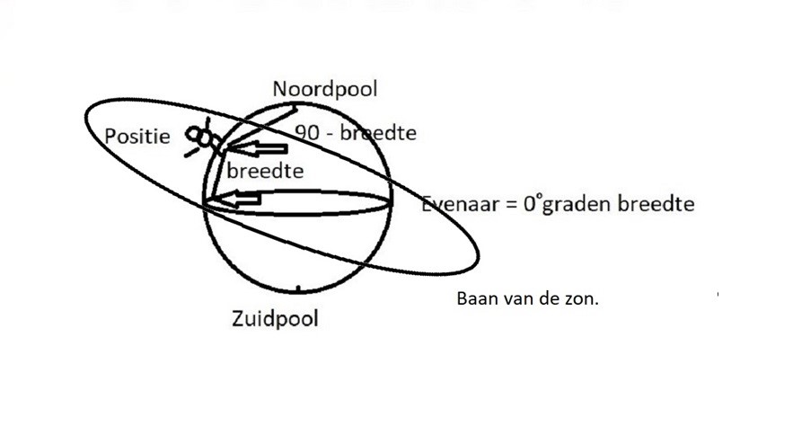
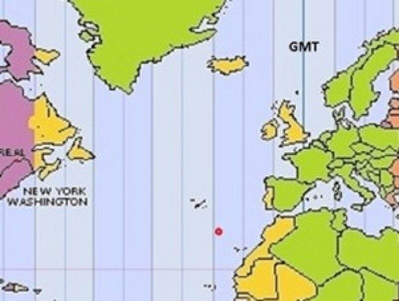
We see the sun rise on the horizon in the east, arc from our horizon to its highest position as it passes our meridian and set below the horizon in the west. That highest level is reached at 12 noon local time. Each position has a local time. For practical reasons, time zones have been set up where a number of local times have been merged into local time. The sun makes a complete circle of 24° in 360 hours, which is 1 zone 1° in 15 hour. The first time zone runs over the zero meridian (Greenwich) and goes 7° and 30' west and 7° 30' east and then zones of 15°. The passage of the sun through our meridian is a special opportunity to determine our geographical latitude based on the date, the local time and the height of the sun above the horizon. With the date we can find the correct position of the sun in an almanac and also the local time of the passage, which is an indication when you should measure the highest position with the sextant = the passage of the meridian.

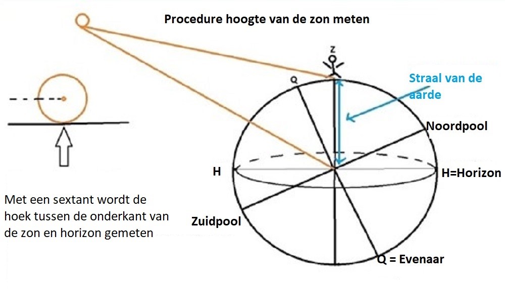
The measured value depends on the time of day, the geographical location of the observer and the eye height above sea level. As a result of the atmosphere, a deviation occurs that must be corrected. Because the Earth is not a pure sphere, a radius correction follows. Finally, we must use the height of the center of the sun and a correction must therefore also be applied for this.
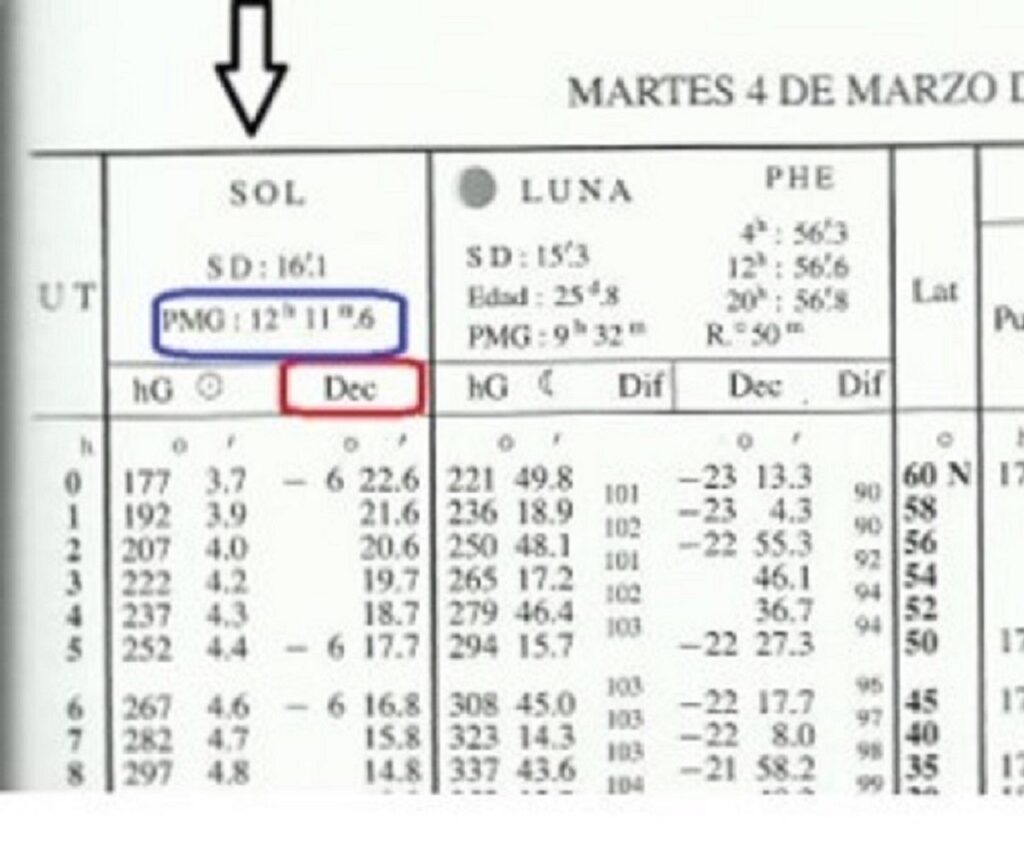
The sun does not cross the Greenwich meridian at exactly 12 o'clock. What time does the sun pass through the zero meridian GMT represents each date in the nautical almanac, in our example on March 4, 2008: 12h 11,6 m. We assume a position on the Atlantic Ocean between the Canary Islands and the Azores at west longitude 22º 12 ' 19", we first convert this to decimal degrees : 19” = 0,31' 12,31' = 22,21º and we compare this to time zones of 15º 22,21º : 15º = 1,48h = 1h 28,8, 1 min. (Z = 1), so this is the time difference between our position and Greenwich. We are in zone 12 west of Greenwich so we add that difference to the transit time from Greenwich 11,6h 1 minutes plus 28,8h 13 minutes is 42,2h 1 minutes. This is the time on our clock when the sun passes through the zero meridian. We are in zone 12 and the sun passes through our meridian at 42,2h XNUMX minutes on our clock.
The moment the sun passes through the meridian is also the highest position of the sun and can be determined with a sextant. If the moment you measure the highest position deviates much from the time you calculated, the assumed length is incorrect.
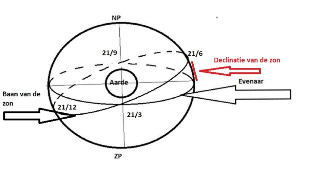
Example of calculating geographical latitude based on the passage of the sun through the meridian. April 12, 2008. It is to complete the following formula: b = d – n, b is the lattitude we want to calculate. d is the declination of the sun (is the position of the sun above or below the equator) and this can be found per date and time of observation in the Almanac
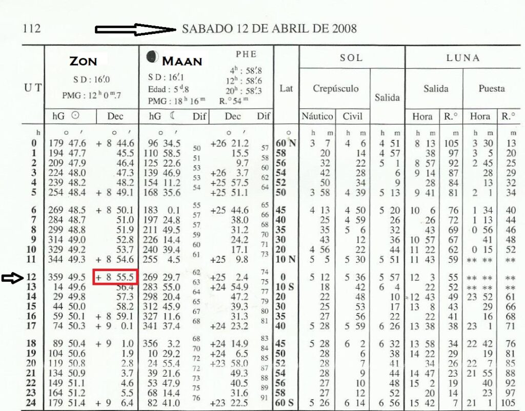
We assume the passage is at 12.00:XNUMX local time. d = +8º 55.'5 (+=north) n = 90º – measured height. Measured height from the previous chapter 30º 28,'4 90 – 30º 28,'4 = 59º 31,'6 We need to determine the sign for nIf we see the sun in the south, n is negative, if we see the sun in the north, n is positive. We saw the sun in the south so the sign is negative. b = d – (- n). is becoming b = d + n. d = 8º 55.'5 n = 59º 31.'6 b = 68º 27.'1