Weather reports
Before sailing you want more information than rain or sun. A very reliable address for paddlers is www.passageweather.com. It does require some attention to read the cards and therefore some explanation here. Recognize on the map with the wind forecast what is land and what is water and where you are. The wind direction and strength are important, where we take the direction from the compass. There are several options for power. The Beaufort scale, km per hour, PassageWeather uses Knots = knots. A knot is one nautical mile per hour. For orientation: Beaufort wind force 3 is 7 to 10 knots or 12 to 19 km per hour. Higher altitudes in the Mediterranean are only accessible to larger yachts. In the short term, an adjustment every 3 hours, later larger intervals. The force is indicated with colors, the direction with dashes and small dashes on the back to also indicate the force. We call the direction of the wind from which it blows.

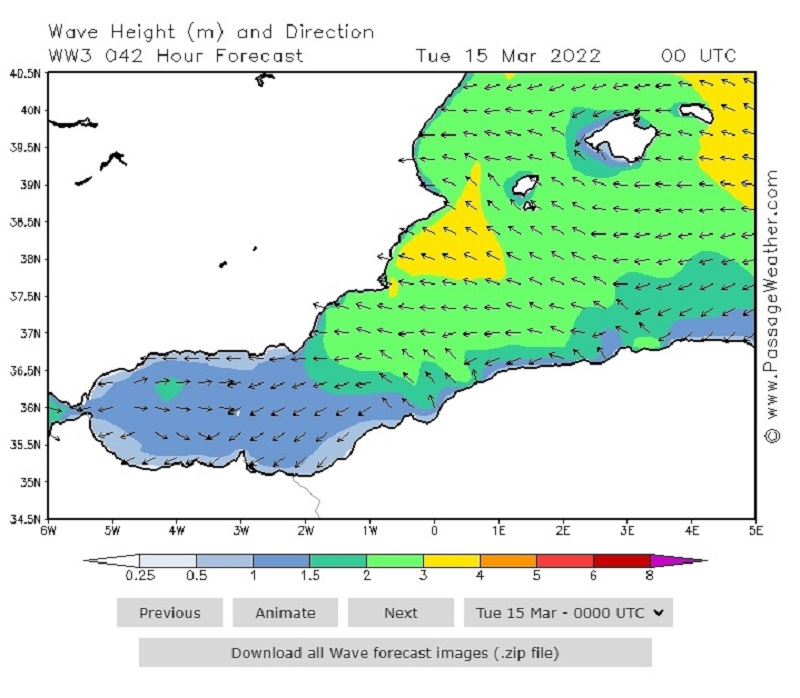
The wave forecast makes it easier to recognize what land and sea are. The expected wave direction is indicated with arrows and the wave height, calculated from crest to trough, in meters with colors. The wave direction is named after the direction in which it moves.
Beaufort for the practice man on the hand of the sea
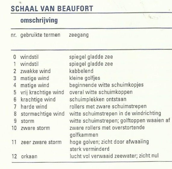
Wind force 4
Oceanography
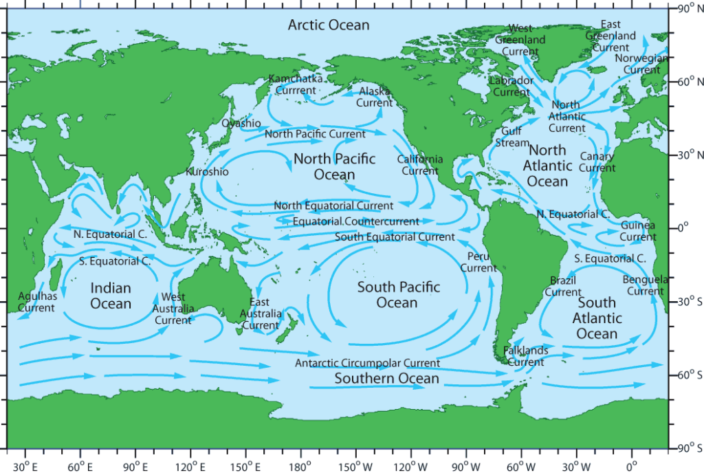
Ocean currents are movements of large bodies of water across oceans or seas. The large amount of energy it carries in the form of heat or cold exerts much influence on the climate of the area through which it passes. Origin of the currents: a) By change in density due to variations in temperature and salinity of water masses. As it evaporates, the water from the surface becomes saltier, denser. (
TIDAL CURRENTS
The variation in the level of the water generates important currents, especially in narrow and shallow places, where they usually acquire large speeds. In a canal, the speed of the water is maximum in the middle and minimum in the banks, where in many cases a countercurrent occurs. Tidal currents are usually called ebb and flow, depending on whether the water is rising or falling. They are periodic and alternate, depending on the geographical latitude and the position of the sun and moon.
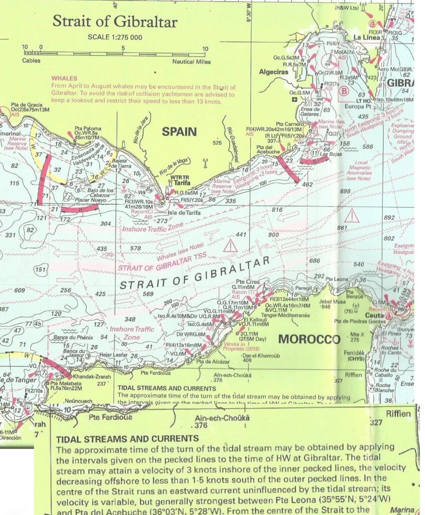
Rijkswaterstaat provides information about high and low water levels for the various ports on the North Sea coast and wadden. What must be kept in mind is that the high and low tides are not a turning point in the currents. For example, near IJmuiden there is a northward current from 2 hours before to 4 hours after high tide IJmuiden. Spring tide = when the sun and moon cooperate with each other is 2 days after the full and new moon. The Hydrography Service of the Ministry of Defense produces many publications, also digital, such as The Netherlands Coast pilot, List of Lights, Water Levels and Currents, Sea Charts.

Hurricanes (Cyclones)
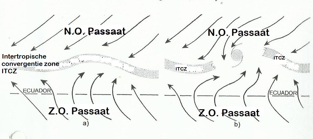
A cyclone originates in the tropics or subtropics, usually around a low-pressure core in the intertropical convergence zone, where the trade winds of both hemispheres meet. Tropical cyclones consist of homogeneous hot air. Wind intensity increases as distances from the core shorten and the direction of rotation converges counterclockwise in the Northern Hemisphere.
Characteristics.
- They have no fronts because they consist of a single mass of homogeneous equatorial air
- The energy of tropical cyclones comes from the latent heat of vaporization released by very moist air that condenses.
- The air pressure of the cyclones can reach 930 mb.
- The geographical situation and the time of year determine its formation
- Hurricanes break up as they enter land because their energy source, water vapor, disappears.
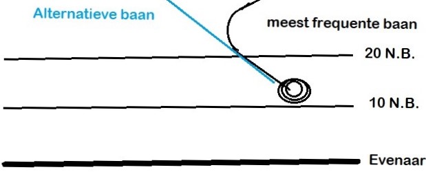
- Initially the path of hurricanes is NW.
- According to the speed of their winds, tropical cyclones are classified as:
- a) Tropical calm when the cyclonic circulation is weak.
- b) Tropical depression when the wind does not exceed 34 knots.
- c) Tropical storm when the wind does not exceed 47 knots,
- d) Hurricanes with a wind force of more than 65 knots. Trajectories.-
- The trajectories have a parabolic shape. Initially they move west almost parallel to the equator, later they open from the equator and move WNW in the Northern Hemisphere and then turn NW, continuing to turn N and NE at latitudes between 30º and 40º N.
Conditions necessary for cyclone formation.
- Low pressure centers in the ideal places of the intertropical convergence zone
- High pressures in the troposphere, during which there will be divergent winds that will expel the air from the upper vertical part where the cyclone forms, that is, facilitate the ascent of warm air; so that the chimney has more draft
- High temperature of the water so that there is strong evaporation (more than 24º)
- Favorable winds at the level of the atmosphere, that is, x weak winds that allow the rapid rise of surface winds. Life cycle of tropical cyclones.
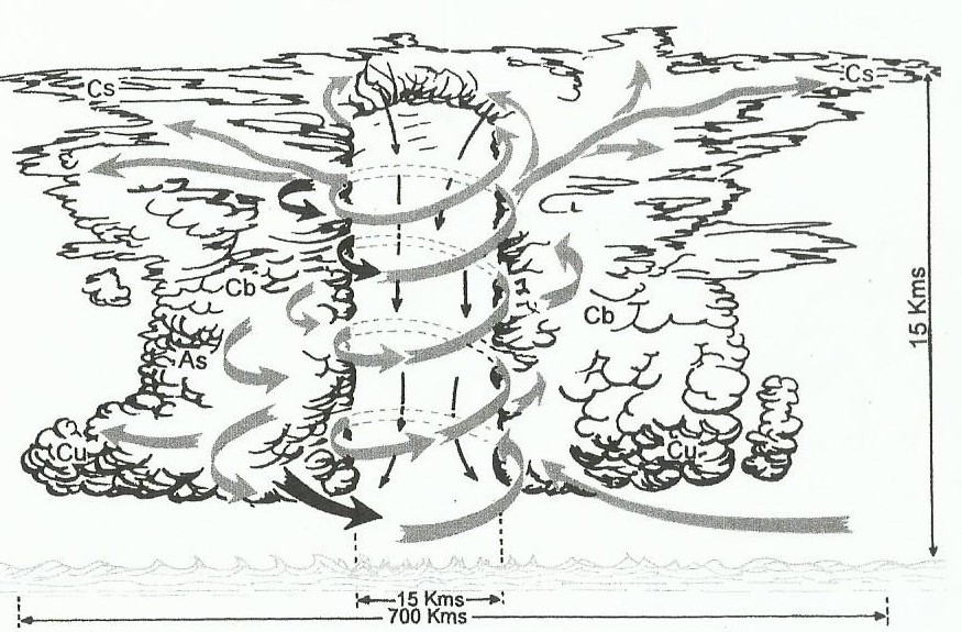
The life cycle of a tropical cyclone can be divided into 4 phases: formation, development, maturity and old age or decomposition. - In the formation phase, the ideal conditions exist for the formation of a cyclone
- In the development phase, the depression deepens and the wind around the low gradually increases, as does the area of influence.
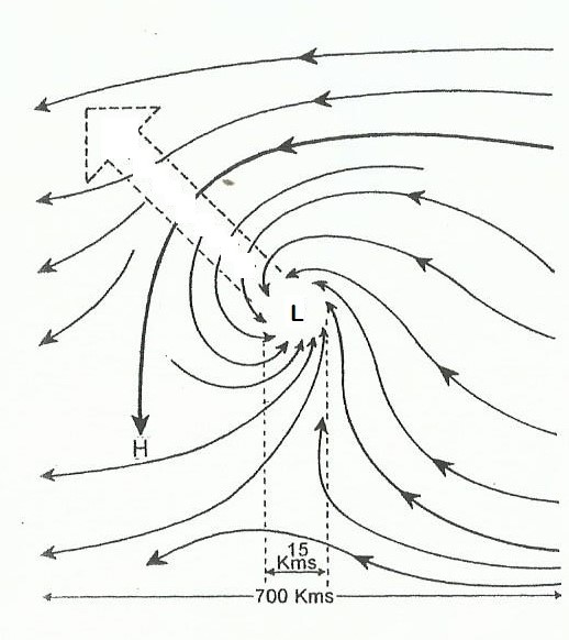
- In the adult stage the pressure stabilizes around 940 mb. The wind is then hurricane force. The diameter can reach 700 km. And their altitude 15.000 meters. Evaporation at the water surface is maximum.
- The stale phase begins when “fuel” begins to become scarce, that is, when there is a lack of water vapor in the warm air. This happens when water temperatures drop at higher latitudes or when the cyclone enters land.
DANGEROUS AND NAVIGABLE SEMI-CIRCLES
As the wind turns towards the center, as the speed increases
(due to the increase in the horizontal pressure gradient) the angle of the wind with the isobars decreases until it blows parallel to them. Hence the tranquility of the wind in the vortex or eye of the hurricane. The transition from the zone of high wind speed to the calm zone of the vortex is almost instantaneous.
The speed of the wind increases from outside to inside as the pressure gradient increases and at the same time the angle formed with the isobars decreases.
The strongest winds are found about 35 miles from the center. The circle of the cyclone, looking along its path, splits in two
semicircles: right and left, with the right position considered dangerous and the left position considered manageable in the Northern Hemisphere.
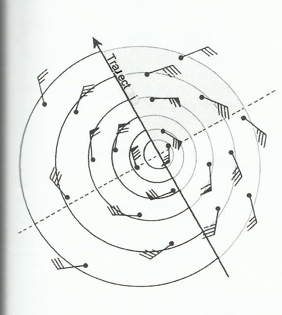
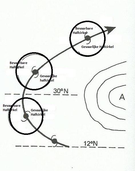
If we draw a line perpendicular to its path and passing through the center of the cyclone, we divide the semicircles into quadrants, the most dangerous of which is the right front quadrant. In the right semicircle the speed of the wind is greater because the translational speed of the cyclone must be added to the speed of the wind.
Determination of the semicircle in which the ship is located.
1 If the wind turns clockwise, we are in the
dangerous semicircle (right).
2 When the wind turns counterclockwise, we are in the manageable (left) semicircle.
If the wind maintains its direction and increases its strength, we will be on track.
4 As the pressure decreases and the wind increases, we are in the right front quadrant.
5 As the pressure increases and the wind decreases, we are in the right rear quadrant. •
Maneuvers if you find yourself in a hurricane:
Situation 1 in the right rear quadrant: keep the wind on the bow and let the hurricane drain.
Situation 2: you are in rough seas and strong winds. Keep the wind on the starboard bow and let the hurricane drain.
Situation 3 in right front quadrant: we are 150 miles from the center with a southerly wind. Because we are far from the center we have to keep sailing into the wind to leave the zone and the wind will turn to starboard.
Situation 4: We will have to move away from the center but cannot sail across the sea, the most recommended option is to keep the wind on the starboard bow.
Situation 5: We are close to the left semicircle and we have to reach it as quickly as possible. We sail with a strong wind on starboard. If the hurricane continues its path, we will continue to sail with a strong wind on starboard, once in the left semicircle downwind.
Situation 6 in the left front quadrant: If the ship can withstand it, we keep the wind straight to get off the track as quickly as possible. If the ship cannot withstand it, sail with a strong wind on the starboard side, ultimately keeping the wind on the starboard bow and later on the bow depending on the speed of the crossing.
Situation 7: Initially with a strong wind on starboard to sail away from the center as quickly as possible, then with winds transverse and on the starboard bow depending on whether the ship can withstand it, but will probably have to continue with a strong wind.
Situation 8 in the left rear quadrant: Sailing with the wind on the starboard bow as we move away from the track with a clear wind.
Situation 9: Sailing with a strong wind on starboard because the ship cannot withstand half wind until we get further away from the track and we can gradually sail half wind and with the wind on the starboard bow.
Situation 10: Sailing with the wind on the starboard bow to sail away from the hurricane and get decreasing winds.